
Pulau Sudong: Fishing village of 400 people turned military zone
This piece is part of MS Explains, a segment where we provide clarity to common or key topics, making them easier to digest.
When one pulls up a map of Singapore, the diamond-shape of the mainland island takes up most of the display.
But, past the southern tip of the main island, there are specks of small land masses that dot the horizon off West Coast beach and the popular tourist destination of Sentosa.
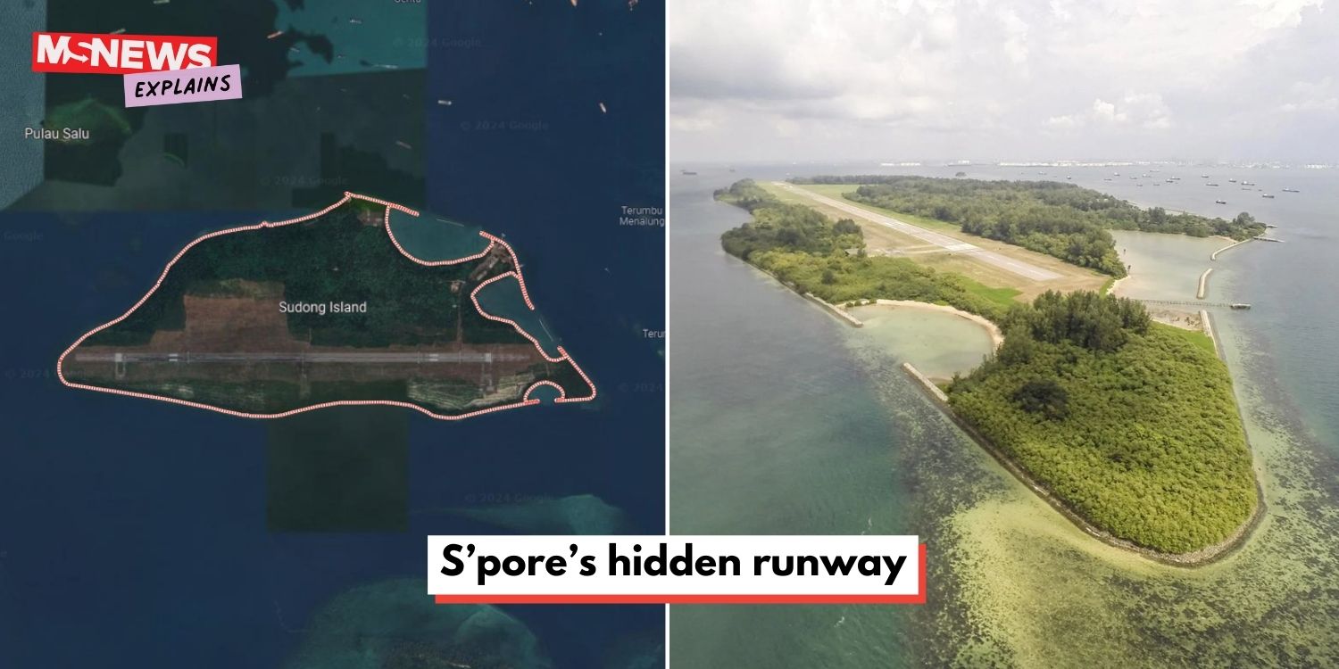
Among them, one small island stands out with what appears to be a 2.5km-long airstrip, visible via satellite imaging: Sudong Island, or Pulau Sudong.
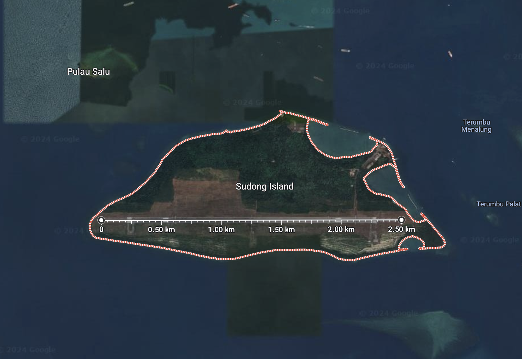
Source: Google Maps
The name of the island came from the shape of its surrounding reef, which resembles a “tudung”; it bears the same meaning as “Sudong” — a scarf that is used as a cover.
It previously housed a village of almost 400 inhabitants before the Singapore Government reclaimed it for further development in the 1970s.
However, plans to convert the island into a resort fell through and it became a military live-firing zone in the 1980s.
This was the status quo until January 2024 when authorities unveiled new plans to reclaim more land to expand the existing airstrip.
Pulau Sudong housed almost 400 inhabitants, had vibrant community
Houses built on stilts over the water, no roads, or flush toilets in sight.
This was Pulau Sudong in the 1960s and even up to the 1970s, according to a report by the New Nation from that time.
Since the 1940s, Pulau Sudong was under the jurisdiction of the Singapore Rural Board (SRB).
The island was home to around 390 residents in the 1960s, in which many of its inhabitants, mostly Malay, made a living by fishing.
These islanders lived a simple life, although once a year, Pulau Sudong residents looked forward to a lively sports meet known as ‘Pesta Five S’.
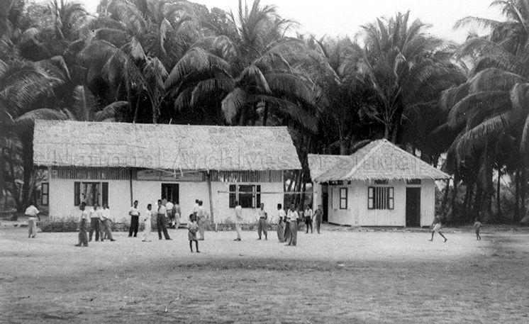
Source: National Archives of Singapore
During this event, Pulau Sudong also hosted the residents of Pulau Semakau, Sakijang Bendera (now St John’s Island), Pulau Seking, and Pulau Seraya.
The sports meet, which involved games such as tug-of-war and soccer, as well as water sports, took place all the way until the later half of the 1970s.
“For the men, you have the races with their ‘jongs’ or their boats,” recalled Mdm Halimah Daud, a former resident of Pulau Sudong from 1960 to 1977.
“On land, there will be many women with games such as arranging or searching for photographs.”
Other games include searching for a sweet in flour or putting a thread through a needle, she added.
Islanders make room for development
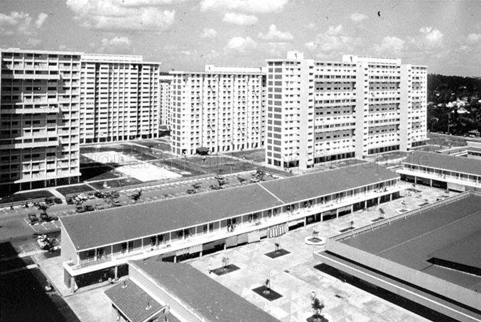
By the mid 1970s, residents of the island were facing pressures to modernise.
After all, there were large-scale developments happening on mainland Singapore, most apparent in the housing projects.
Source: National Archives of Singapore
Minister for Social Affairs at the time, Mr Othman Wok, urged the island community to prepare for change.
“We must together learn to adjust to the changes and build our environment to take advantage of modernisation and technology,” he said during the 1975 ‘Pesta 5 S’ at Pulau Sudong.
“Societies like ours must be strong in social discipline. We must know what our collective interests are and what adjustments we must make to the changing circumstances.”
Less than a year after this speech, the Port of Singapore Authority (PSA) announced plans to reclaim Pulau Sudong and the nearby Pulau Biola for development projects by the Sentosa Development Corporation (SDC).
Plans to transform the island into a holiday resort
Whether the islanders knew it or not, Pulau Sudong had already been earmarked for industrial development, reported ST in 1976.
However, the island was then deemed unsuitable for whatever Jurong Town Corporation (JTC) had planned — hence the pivot to recreational development.
In Oct 1976, the PSA awarded contracts to companies Toa Harbour and Swee Construction for reclamation and shore protection projects on Pulau Sudong respectively.
The goal was to build two lagoon beaches on the island, turning them into island resorts.
Reclamation works launched two months later, but there were no concrete plans to follow-up on developing the land into recreational attractions.
The reclamation works in the 1970s had expanded Pulau Sudong by about 242.82 hectares, reported ST.
Pulau Sudong joins two other islands for military use in 1980s
Within the next decade or so, Pulau Sudong would enter its military era.
A report from 1982 announced that the island was temporarily closed to the public due to live-firing exercises by the Singapore Armed Forces (SAF) on nearby Pulau Senang.
The SAF officially gazetted Pulau Sudong as one of its official live-firing areas in 1989, along with Pulau Pawai and Pulau Senang.
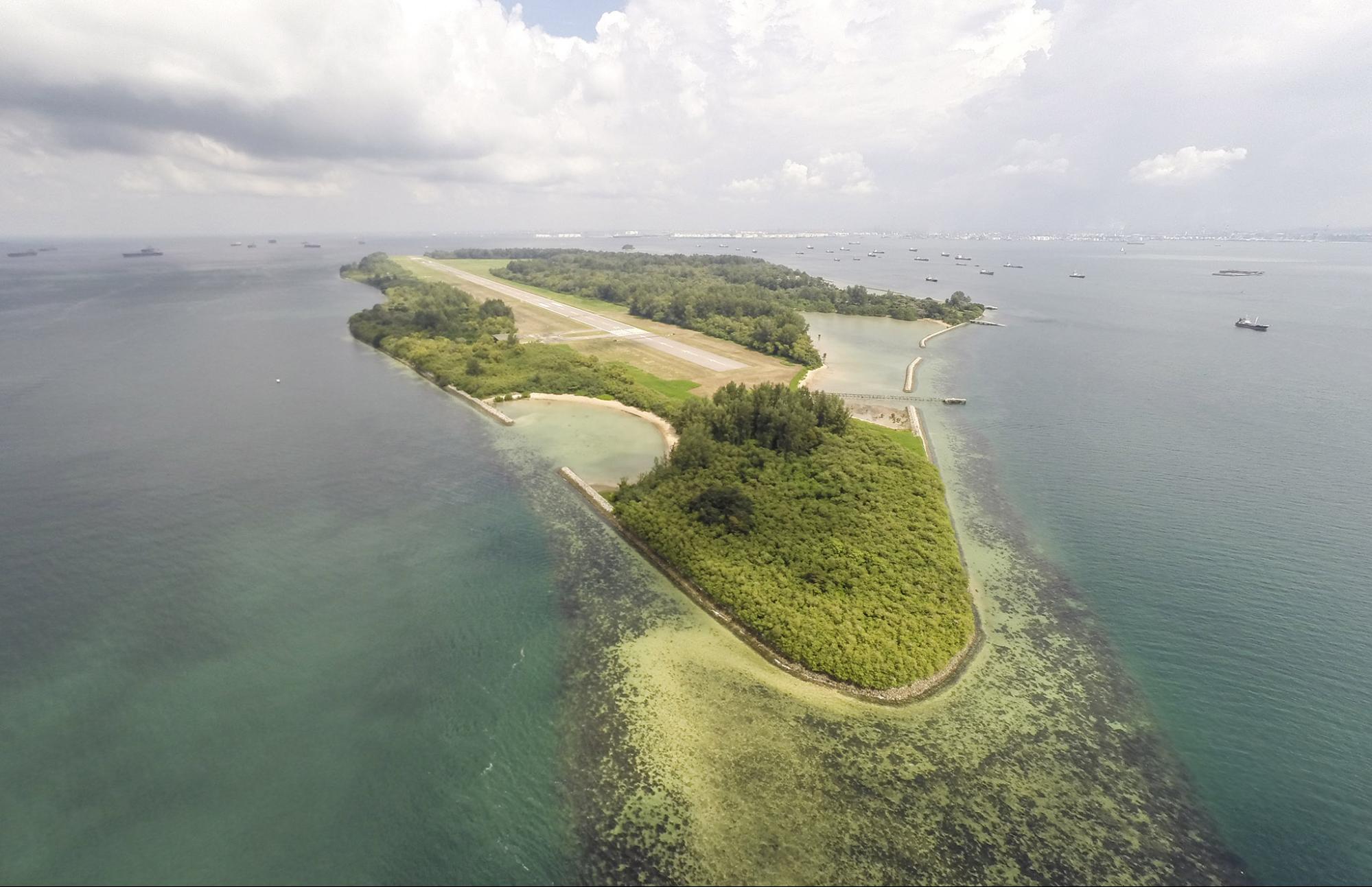
Eventually, Pulau Sudong had a military runway that spanned the length of the island.
Though official reports of the airstrip are few and far between, The Business Times reported in 1994 that L&M, a specialist construction company, won an award that year for its work on an airport runway in Pulau Sudong.
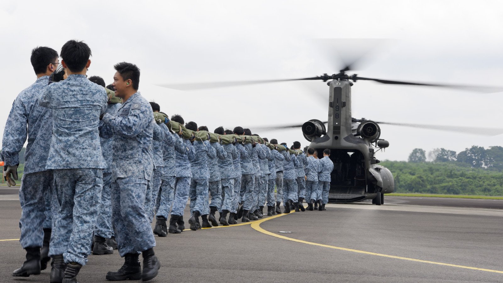
Pulau Sudong, Pulau Senang, and Pulau Pawai have been used for military purposes ever since the 1980s.
“These islands [Pulau Sudong, Pulau Pawai, and Pulau Senang] provide for emergency recovery for RSAF aircraft, air-to-ground firing, as well as demolition activities,” said Mike Lim of the OIC Support Facilities Section in an RSAF clip.
As it turns out, Pulau Sudong is also used during Singapore’s National Day celebrations — specifically during the preparations for the Singapore flag fly-past.
Source: MINDEF
The Republic of Singapore Air Force (RSAF) continues to conduct live-firing exercises at the Southern Islands Live Firing Range.
In April 2023, the SAF also advised the public to keep clear of Pulau Sudong and the other islands due to demolition activities, on top of live-firing.
“Some loud noises may be expected,” said the advisory.
Existing military airstrip to be expanded starting 2024
So, what is the current status of Pulau Sudong and its airstrip?
In January 2024, the Housing and Development Board (HDB) announced plans to reclaim more land around the island.
Source: Project Island Nation
ST reported that HDB will reclaim around 31.1 hectares of land — equivalent to 43 football fields — on the eastern end of the island in 2024, in order to expand the existing runway for military aircraft.
At present, the airstrip is slightly less than 2.5km long. In comparison, Changi Airport’s two runways measure 4km each.
The upgrade will improve flight safety on Pulau Sudong’s emergency airstrip, especially during bad weather, HDB told ST.
To mitigate the environmental impact of the reclamation on the surrounding coral reefs, seagrass habitats, and mangrove forests, the relevant authorities will relocate the rare and vulnerable species on the island.
Additionally, HDB said on 26 Jan that there will be works to restore the habitat once the reclamations are complete by 2028.
Also read: Pulau Senang: S’pore’s prison island experiment that went up in flames
Pulau Senang: S’pore’s prison island experiment that went up in flames
Have news you must share? Get in touch with us via email at news@mustsharenews.com.
Featured image adapted from Google Maps and Project Island Nation.