Cross Island Line Links Hougang To Pasir Ris Within 3 MRT Stops Instead Of 12
The Cross Island Line (CRL) – aka Light Green Line – has finally been green lit, after 6 years of discussions on how to balance nature conservation & construction costs.
Here’s a look at the plan that will see us through to 2029 when the first half of the CRL is expected to be up and running.
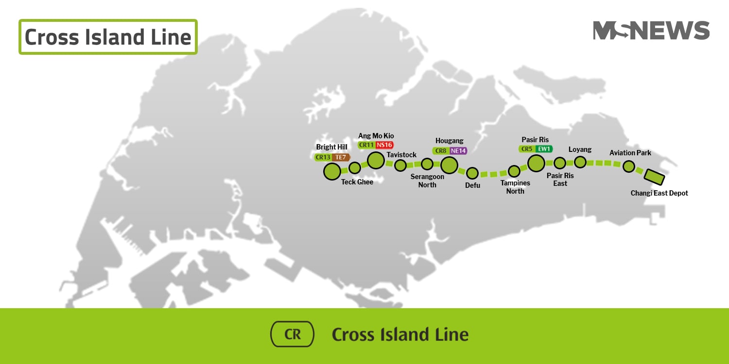
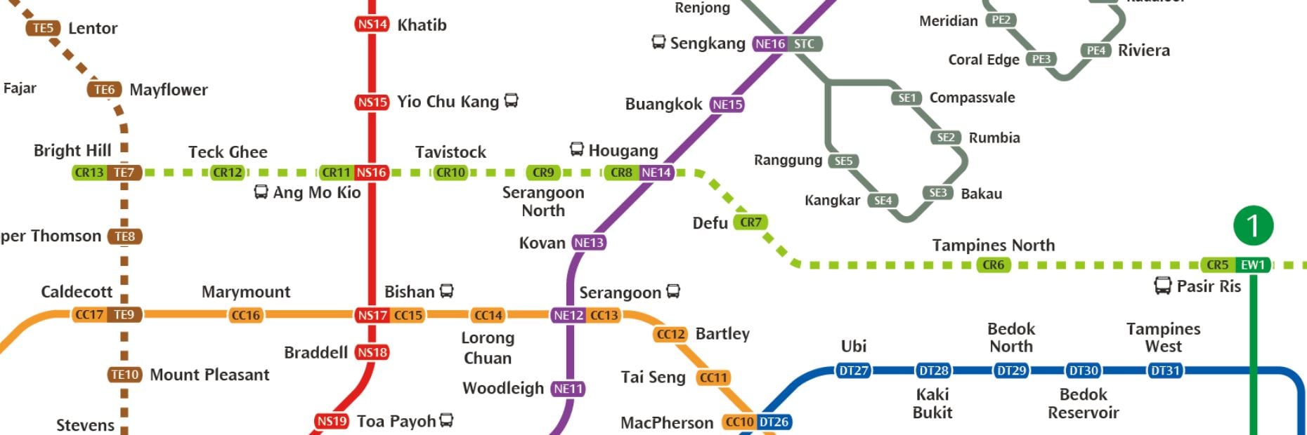
Do note that this map we have created isn’t geographically accurate and is for illustration purposes only.
Direct links from Ang Mo Kio to Hougang to Pasir Ris
Ang Mo Kio residents will have much to rejoice about, barring concerns about human traffic during rush hours.
Ang Mo Kio MRT Station looks set to become the next Bishan Interchange, linking Hougang and Pasir Ris to Singapore’s centre within 3 stops.
The Cross Island Line will cut across 4 different lines (Green, Purple, Red & Brown), providing greater connectivity and a way more efficient way to change train lines.
Pasir Ris to Hougang in 3 stops instead of 12
For instance, getting from Pasir Ris to Hougang MRT currently requires these steps:
- Pasir Ris change to Blue Line at Tampines (1 stop)
- Change to Circle Line at MacPherson (6 stops)
- Change to Purple Line at Serangoon (3 stops)
- Alight at Hougang MRT (2 stops)
With the CRL, commuters will get from Pasir Ris to Hougang in just 3 train stops, greatly cutting down travelling time.
We’ve previously reported on how a trip from Punggol to Pasir Ris is also expected to only take 15 min by train here.
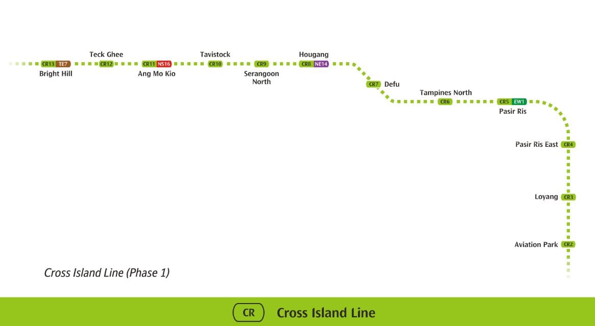
12 new stations linking 4 train lines
For future reference, here’s the complete list of confirmed Phase 1 stations and their interchanges:
- Bright Hill – Thomson-East Coast Line Interchange (Brown Line)
- Teck Ghee
- Ang Mo Kio – North-South Line Interchange (Red Line)
- Tavistock
- Serangoon North
- Hougang – North-East Line Interchange (Purple Line)
- Defu
- Tampines North
- Pasir Ris – East-West Line Interchange (Green Line)
- Pasir Ris East
- Loyang
- Aviation Park
Bright Hill’s interchange will help link commuters working in the Woodlands & Stevens area back home to heartland districts like Hougang and Pasir Ris via the Cross Island Line.
Digging deeper to avoid wrecking nature reserves
When plans to construct the Cross Island Line were first released, conservationists were concerned about the environmental impact of the train tracks cutting across nature reserves.
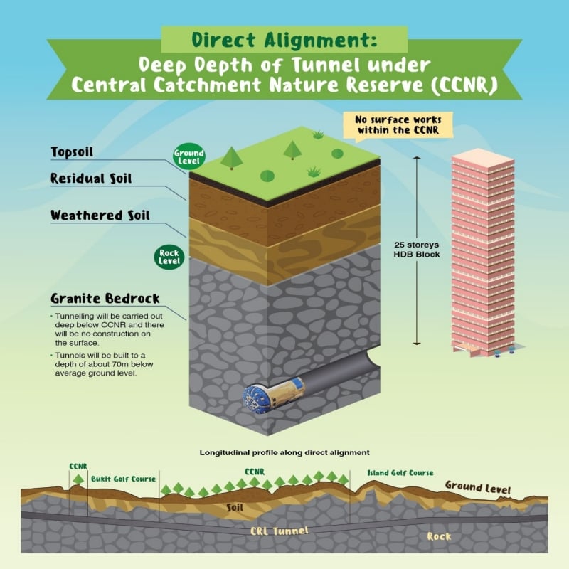
Land Transport Authority’s (LTA) solution to construct a direct line, and minimise disruption to nature, is to drill down deep to bedrock to build an underground train tunnel.
On average, the tunnel will be built 70 metres underground. That’s 25 storeys below ground level on granite bedrock.
LTA also confirms that there’ll be no construction on the surface, and the CIL will be the deepest underground train line after the Downtown Line’s Bencoolen MRT (43m) and Promenade MRT (42m).
As opposed to the skirting route, a direct line will reduce travel time by 6 minutes and construction costs by a whopping S$2 billion.
Ministry of Transport also claims that the direct line will be more “environmentally friendly” in the “longer term” as it has a “lower energy consumption”.
About 2 years till construction begins
TODAY reports that the next steps will be to await “advanced engineering studies” which “typically take up to 2 years”, before construction on the rail begins. Tenders for the project, however, have already been launched.
LTA expects the Cross Island Line to support upcoming BTO neighbourhoods in the North-East of Singapore, like Punggol, Hougang & Sengkang.
2029 can’t come soon enough
Current plans for the CRL are only the tip of the iceberg as the final line will have 30 stops, continuing along the central to west side of Singapore.
Along with these 12 confirmed stops, we can expect another 18 stations to be built in stages by 2030.
Are you looking forward to the new Cross Island Line? Or do you still have concerns about the environmental impact of the new train tunnels?
We’d love to hear your thoughts in the comments below.
Also read:
Cross Island MRT Line Gets You From Punggol To Pasir Ris In 15 Min, Phase 1 Opens In 2029
Featured image adapted from Land Transport Authority & Free Vector Maps.


